Most people fly into Liberia, drive an hour to Tamarindo, and surf the mellow river-mouth waves in front of town with sixty other people. Playa Grande is the beach on the other side of that estuary. Same swell, better sandbars, a fraction of the crowd, and a national park behind it instead of a construction site.
It is not a secret — it has hosted contests and it fills up in the dry season — but it stays a different experience, and the reason is regulatory rather than geographic. The beach sits inside Parque Nacional Marino Las Baulas, a leatherback nesting sanctuary. Building heights and beachfront development are restricted, the beach closes to unguided visitors at night during nesting season, and the practical result for a surfer is a long strip of sand with jungle behind it instead of a wall of condos.
The wave
Playa Grande is a beach break, and it behaves like one. There is no reef holding the shape in place, so the peaks move with the sand, and the sand moves with the season. What stays constant is the exposure: the beach faces roughly west, sits open to the Pacific, and picks up swell from both hemispheres. That is why it is on almost every "consistent" list for Costa Rica — it is very hard to arrive here and find nothing at all.
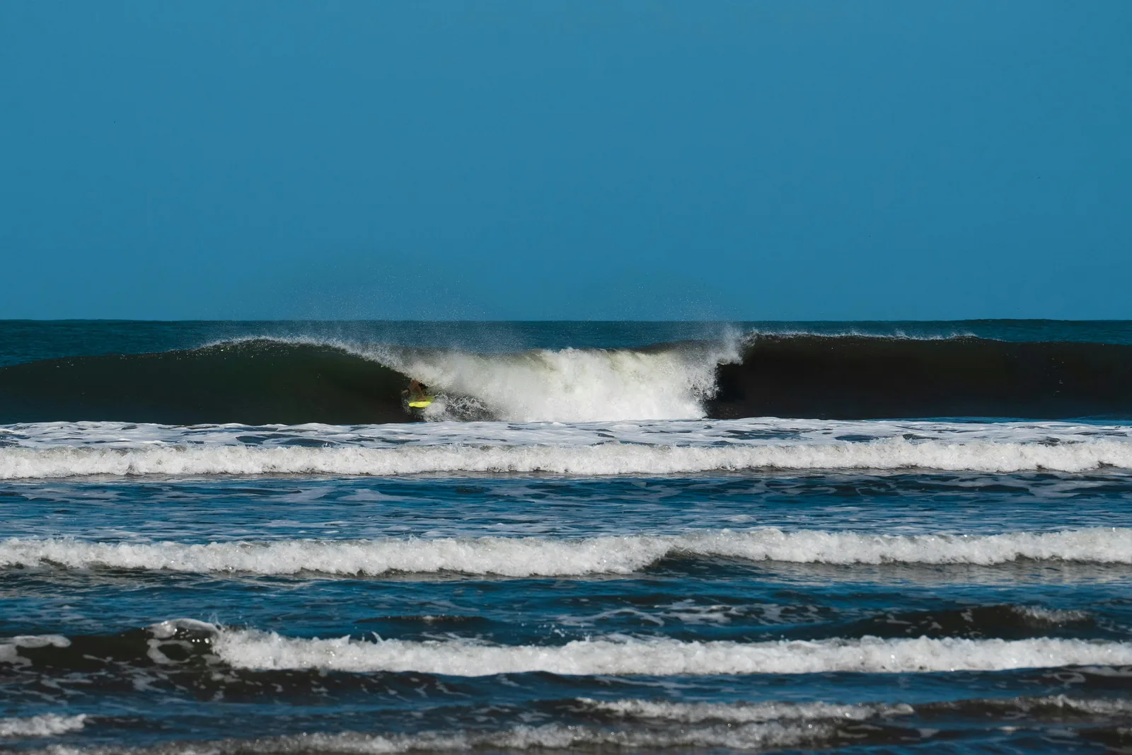
The wave itself is punchier than Tamarindo across the water. Sandbars stack into A-frames that give you a short, fast wall in both directions, and on a good bank with size behind it, a real barrel section. It is a rippable, powerful, sometimes closed-out beach break — not a long peeling point. Plan your board choice around that: something with a bit of life in the tail for the small days, and something you can get under a lip with on the bigger ones.
It works through most of the tide, which is the practical reason it is worth building a trip around. Low tide tends to be steeper and shorter; the incoming push is generally the friendliest window and where the banks open up. Costa Rica's tidal range is significant — a couple of meters between high and low — so the same sandbar genuinely is a different wave four hours later. Check the tide before you commit to a session, not after.
When to go
Two seasons, and they trade the same thing back and forth: the dry season buys you wind and costs you swell, the green season buys you swell and costs you wind.
Dry season — December to April
- Swell: NW and N groundswell, less consistent, generally smaller
- Wind: Papagayo offshores, often all morning and sometimes all day
- Crowd: Peak season, the busiest the beach gets
- Water: Board shorts, high 70s to mid 80s °F
This is the postcard version. The Papagayo winds blow out of the northeast across the Guanacaste lowlands, which on a west-facing beach is straight offshore, and they hold the wave up beautifully — that feathering crest in the photo above is exactly what a good offshore does to a peak. The trade-off is that the North Pacific has to actually send something, and the NW swell window here is narrower than the southern one. You can get four flawless, glassy, waist-high days in a row and wish for more push.
The other trade-off is that Papagayo can overdo it. When it really honks, offshore stops grooming and starts wrecking — it holds the lip up so long that the wave will not break properly, and paddling into anything becomes work. Dawn is usually the sweet spot before it builds.
Green season — May to November
- Swell: SW groundswell from the Southern Hemisphere, consistent and with real period
- Wind: Lighter and more variable, best in the early morning
- Crowd: Noticeably thinner, especially September and October
- Water: Warm, and the rain is warm too
This is when the wave gets good, and it is the season most traveling surfers underrate. The Southern Hemisphere fires storms into the South Pacific from roughly April through October, and that energy arrives here with long period and real weight behind it. The swells are more consistent, bigger on average, and the wind is generally calm enough in the morning to leave the surface clean.
"Green season" means rain, but it usually means afternoon rain — mornings tend to be the clear, surfable window, and the landscape is spectacular rather than dusty. September and October are the wettest months and, not coincidentally, the emptiest. If you can tolerate an afternoon downpour and a muddy road, that is the window where you get the best waves with the fewest people.
If you want one answer: go in the shoulder. Late April, May, and November tend to hand you southern swell with dry-season-ish wind, which is the combination the two seasons otherwise keep apart.
Logistics
Fly into Liberia (LIR), not San José — it is roughly an hour and fifteen minutes of easy driving versus most of a day. Rent something with clearance if you are going in the green season; the last stretch of road is not paved everywhere and rain finds the potholes.
Stay in Playa Grande, not Tamarindo, if the surf is the point. The whole advantage here is walking to the beach at first light instead of driving around an estuary to get to it. Accommodation is smaller-scale by law — guesthouses, small hotels, rentals — and it books out in the dry season, so plan further ahead than you would for the green season.
Do not paddle across the estuary. The channel between Playa Grande and Tamarindo looks like a shortcut and is not one — it moves fast on the tide, and there are crocodiles in it. Take the boat taxi or drive around. This is local knowledge that every guide repeats because visitors keep testing it.
Respect the turtle rules. Leatherbacks nest here from roughly October to March. That means restricted beach access at night, no lights on the sand, and guided-only visits during nesting hours. The rules are the reason the beach looks the way it does; they are worth keeping.
Rips are the real hazard. It is a beach break with strong currents, and the channels that make the sandbars work are the same channels that will take you down the beach without your noticing. Pick a landmark on the dunes, check it every few waves, and paddle in rather than fighting straight back to it.
Reading the forecast for it
A beach break rewards forecast-reading differently than a reef does. A reef has one shape and you are waiting for the right size and direction to switch it on. A beach break's shape is unknown until you look at it, so what you are really forecasting is the conditions around the sand — and three numbers do most of the work.
- Direction first. In the green season you want SW in the swell direction; in the dry season you are waiting on NW. A big number pointed the wrong way through the window does you no good.
- Period tells you what will actually arrive. Long-period southern energy — 15 seconds and up — travels with real weight and will break with authority even when the height number looks moderate. Short-period wind swell at the same height is a mushy, disorganized day.
- Wind decides the day, not the swell. On a west-facing beach, northeast is offshore and anything with west in it is onshore. In the dry season, the question is not whether it is offshore but whether it is too offshore by mid-morning. Check the hourly, not the daily average.
Then look at the tide against your session window, and go early. That sequence — direction, period, wind, tide — is how a beach break trip stops being a lottery.
Pull up Playa Grande in Fetch before you book and watch it for a couple of weeks. You will learn the rhythm of the place faster from a fortnight of forecasts than from any guide, including this one.
Swell, wind, and tide for Playa Grande and 7,500+ other spots, live in Fetch.